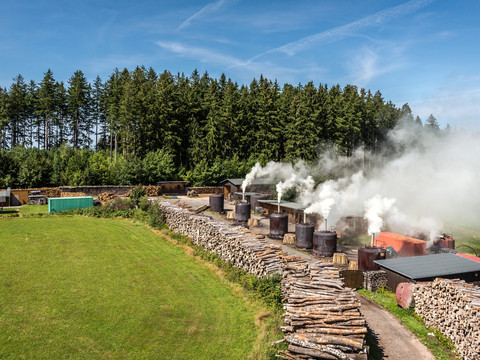
Our tour starts at the central signpost in the center of Sosa, directly opposite the church. We initially cycle north-west along the main street of the charcoal-burning village before turning left after 600 m onto Eibenstocker Weg and heading west to the end of the village.
After 2 km, the cyclist reaches the forest, where the route continues. At a crossroads at the edge of the forest, follow the signpost towards Zimmersacher (1.4 km).
At 2.7 km, you reach a crossroads with a bridge where the Kleine and Große Bockau flow together. Now turn left and the tour follows the Große Bockau, one of the most beautiful river valleys in the region (nature reserve!). If you turn right at the junction, heading north, you will reach the Blauenthal waterfall, the largest waterfall in Saxony, after just 1.4 km.
Especially on hot summer days, you can enjoy the cycle tour here in the Bockau valley in the cool forest air, although the route now climbs steadily for 8 km (from 500 m to 800 m).
At km 4.4, cyclists reach the Wettin Stone, a granite memorial stone in honor of the Saxon Wettin dynasty. Granite rocks accompany us on the entire tour. There is a refuge opposite the Wettin Stone at the Rector's Bridge.
During the trip, you should always take a break on warm days. Shallow spots in the river invite you to refresh yourself with cool, clear mountain water. But be careful! After heavy rainfall, the Große Bockau carries a lot of water and develops a torrential current.
At km 6, the cyclist reaches another refuge in the Bockau valley, shortly afterwards a bridge over the river, so that the path continues to the left of the Große Bockau.
After 8.5 km, you reach Wildenthal at a 3-way junction. Here you will also find an orientation board and the next signpost "Talsperrenrunde". The tour now turns 180 degrees and heads slightly uphill again to the north. Wildenthal is a state-approved resort and is located on the long-distance hiking trail "Kammweg" (www.kammweg.de).
Wildenthal and the area around the Auersberg are also a drinking water catchment area. The Hanggraben, a canal system that feeds the reservoir with fresh water, runs along the western and southern mountain ridge. You can fill up your water bottle here without hesitation.
The next striking point on the tour is km 10.6: Großer Stern. At 800 m above sea level there is a refuge with a rest area. From the Großer Stern, paths branch off in five directions. Sporty hikers follow the Ringweg (1.8 km, 200 m) to the Auersberg summit at 1018 m, the highest point in the Westerzgebirge (mountain inn, kiosk, observation tower). This section is part of the Erzgebirgstrail Stoneman Miriquidi (www.stoneman-miriquidi.com). Due to its steepness (1.4 km, 200 m), the direct route to the Auersberg via the middle wing is only accessible by mountain bike and for very well-trained athletes.
After the detour to the summit, ride back the same way and follow the "Talsperrenrunde" signs northwards from the Großer Stern. From now on, the bike rolls comfortably downhill towards Sosa.
Caution! Do not miss the turn-off to the right after approx. 400 m on the descent. On the following fast descent, you should bear in mind that hikers and forestry vehicles are often on the way. Ride on the right, be considerate of others and stay ready to brake! But who wants to race through beautiful nature?
At km 13.2, the descent ends at a T-junction, turn right here and head south/south-east. The route now runs above the banks of the dam. The forest road ends at km 14.9 at an asphalt road, which we follow to the left again heading north.
Before cycling down to Sosa at the end of the tour, you should take the left fork towards the dam wall at the "An der Talsperre" parking lot (17.5 km). At the end of the road (only 0.5 km), you can once again enjoy a beautiful view of the dam, the dense forest and the Auersberg peak and learn interesting facts about the construction of the dam from information boards. Alternatively, a path leads from the parking lot to Seydewitz-Blick, a viewing rock.
From here, take the same route back towards the parking lot and then the road down the valley directly into Sosa to the starting point at the church.
The Sosa dam circuit is a side route of the "Karlsroute" between Aue in Saxony and Karlovy Vary in the Bohemian Ore Mountains (www.karlsroute.de).

